13.4 Sources of year-2023 activity information
13.4.1 SLT activity data and feedback submittals -all fires
As in previous NEI years, S/L/Ts were asked to submit fire occurrence/activity data for the 2023 NEI. A template form containing the desired format for data submittals was provided to S/L/T air agencies. In total, 38 SLTs submitted fire activity for at least one fire type (prescribed burns, wildfire or agricultural burns). When fire activity were provided by S/L/Ts the data were evaluated by EPA and further feedback on the data submitted by the state was requested at times. Table 13.2 provides a summary of the type of data submitted by each S/L/T agency.
| State/Local/Tribe | Prescribed burns | Pile Burns | Wildfire | Agricultural |
|---|---|---|---|---|
| Alabama | Yes | Yes | Yes | |
| Alaska | Yes | Yes | ||
| Arizona | Yes | Yes | ||
| Arkansas | Yes | Yes | Yes | Yes |
| California | Yes | Yes | Yes | |
| Colorado | Yes | Yes | ||
| Connecticut | Yes | Yes | ||
| Delaware | Yes | Yes | ||
| Florida | Yes | Yes | Yes | Yes |
| Georgia | Yes | Yes | Yes | Yes |
| Hawaii | Yes | |||
| Idaho | Yes | Yes | Yes | |
| Iowa | Yes | Yes | ||
| Kansas | Yes | |||
| Kentucky | Yes | |||
| Maine | Yes | |||
| Maryland | Yes | Yes | ||
| Minnesota | Yes | |||
| Mississippi | Yes | Yes | ||
| Montana | Yes | Yes | ||
| Nebraska | Yes | Yes | ||
| Nevada | Yes | Yes | Yes | |
| New Jersey | Yes | Yes | ||
| New Mexico | Yes | Yes | Yes | |
| Nez Perce Tribe | Yes | Yes | Yes | |
| North Carolina | Yes | Yes | Yes | |
| North Dakota | Yes | Yes | ||
| Oklahoma | Yes | |||
| Oregon | Yes | Yes | ||
| Pennsylvania | Yes | Yes | ||
| South Carolina | Yes | Yes | Yes | |
| TN Shelby County | Yes | |||
| Texas | Yes | Yes | ||
| Utah | Yes | Yes | ||
| Virginia | Yes | Yes | ||
| Washington | Yes | Yes | ||
| West Virginia | Yes | |||
| Wyoming | Yes | Yes | Yes |
Certain preprocessing steps were taken with the S/L/T submitted datasets In order to develop a format that could be ingested into the reconciliation or the emissions estimation tools used by EPA. The names of columns and formats were changed to match what the processors required. Additionally, all datasets were reviewed for invalid locations or those that were spatially identified as occurring outside the submitting state. Obvious location errors, such as those where the latitude and longitude were swapped or a sign was missing, were fixed. Without additional information identifying an activity location within the respective state, these records were dropped. Overall, the records dropped accounted for a very small portion of the total activity.
The temporal approach for the S/L/T varied based on the information provided in the submitted data and direction from the individual agencies. Some states submitted activity without end dates. Each of these states provided directions to assume that all fires lasted for a single day. Where a multi-day event could be matched to HMS detections the number of HMS detections on each day within the event were used to apportion the total event activity. When a spatial and temporal match could not be made between the submitted data a flat approach was used for the multi-day event.
The following states required additional preprocessing steps:
- Kansas and Oklahoma Flint Hills Regions: The Flint Hills grasslands typically have 1 to 2 million acres of prescribed burns each year usually between late February to early May. Kansas Department of Health Environment provided county acres burned information for these prescribed burns for 2023 (Figure 13.2) that cover most of eastern Kansas and 4 additional counties in eastern Oklahoma. Between February 3-May 1 about 1.2M acres were burned in the Flint Hills. The HMS detects for this time period and for these counties (about 22700 detects) were used to temporally and spatially allocate these prescribed burns and the associated estimated emissions.
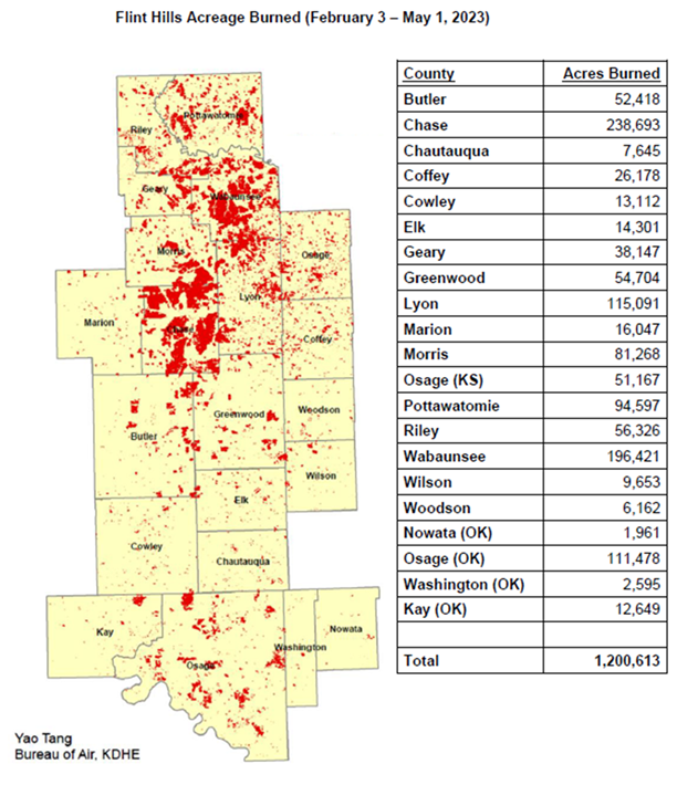
Figure 13.2: Flint Hill prescribed burn acres by county for year 2023 (KS Dept of Health and Environment).
Preparation of the EPA WLF emissions begins with raw input activity data and ends with daily estimates of emissions from flaming combustion and smoldering combustion phases. The daily estimates were summed to monthly and annual for use in the NEI. Flaming combustion is combustion that occurs with a flame. Flaming combustion is more complete combustion and is more prevalent with fuels that have a high surface-to-volume ratio, a low bulk density, and low moisture content. Smoldering combustion is combustion that occurs without a flame. Smoldering combustion is less complete and produces some pollutants, such as PM2.5, VOCs, and CO at higher rates than flaming combustion. Smoldering combustion is more prevalent with fuels that have low surface–to-volume ratios, high bulk density, and high moisture content. Models sometimes differentiate between smoldering emissions that are lofted with a smoke plume and those that remain near the ground (residual emissions). In the 2023 NEI, all flaming emissions are made up of any component that has a flaming component to it while the smoldering emissions are the residual smoldering component that is generated by the CONSUME model. The emissions estimates were estimated and compiled separately for flaming and smoldering combustion phases of fire to facilitate air quality modeling and fine-scale research in areas such as health impacts of smoke emissions, where the known impacts of varying PM and VOC composition by combustion phase likely play a role.
In the 2023 NEI process, EPA developed draft 2023 emission estimates based just on default information. S/L/Ts had an opportunity to review these estimates and: 1) deem them acceptable, 2) submit activity data and a questionnaire (as detailed below), or 3) provide comments. In developing final 2023 WLF estimates, EPA took into consideration all 3 of these items. If an S/L/T accepted the draft estimates, those estimates were not changed in the process to develop final estimates.
13.4.2 National Fire Information Data
Numerous fire information databases are available from U.S. national government agencies. The national fire information databases that were used for the EPA’s 2023 NEI methods for wildland fire emissions estimates include the following:
Hazard Mapping System (HMS)
Agency: NOAA
Format: Comma-delimited
Geographic coverage: North America
Supports all fire type characterization
Wildland Fire Interagency Geospatial Services (WFIGS) Group fire perimeter data
Agency: Multi-federal agency
Format: Shapefiles
Geographic coverage: Entire United States
Source: https://data-nifc.opendata.arcgis.com/datasets/nifc::wfigs-interagency-fire-perimeters/about
Supports mainly wildfires characterization
Incident Command System Form 209: Incident Status Summary (ICS-209)
Agency: Multi-federal agency
Format: Comma-delimited
Geographic coverage: Entire United States
Supports mainly wildfires characterization but some prescribed fires
Interagency Fire Occurrence Reporting Modules (InFORM) Application
Agency: Multi-agency (federal and state)
Format: Comma-delimited
Geographic coverage: portions of the United States
Source: https://data-nifc.opendata.arcgis.com/search?tags=historic_wildlandfire_opendata%2CCategory
Provides additional prescribed burns and wildfire activity not included in above databases
Forest Service Activity Tracking System (FACTS)
Agency: US Forest Service
Format: Shapefiles
Geographic coverage: USFS lands only
Supports mainly prescribed burn characterization
US Department of Interior
Agency: DOI
Format: Comma-delimited
Geographic coverage: DOI lands only
Source: https://ifprs.firenet.gov/arcgis/rest/services/OpenData/IFPRS_Open_Data/FeatureServer
- https://www.nfpors.gov/ no longer operational and replaced with above
Supports mainly prescribed burn characterization
The Hazard Mapping System (HMS) was developed in 2001 by the National Oceanic and Atmospheric Administration’s (NOAA) National Environmental Satellite and Data Information Service (NESDIS) as a tool to identify fires over North America in an operational environment. The system utilizes geostationary and polar orbiting environmental satellites. Automated fire detection algorithms are employed for each of the sensors. When possible, HMS data analysts apply quality control procedures for the automated fire detections by eliminating those that are deemed to be false and adding hotspots that the algorithms have not detected via a thorough examination of the satellite imagery.
The HMS product used for the 2023 NEI inventory consisted of daily comma-delimited files containing fire detect information including latitude-longitude, satellite used, time detected, and other information. Duplicates and those HMS detects estimated to be associated with anthropogenic activity (e.g. solar farms, landfills, mines) were removed before input into SmartFire2 reconciliation tool. HMS detects associated with Flint Hills burning (Figure 13.2) were also removed before input into SmartFire2. The total number of HMS detects used totalled roughly 731,000 with about 24,000 of those detects associated with the Flint Hills burning.
Wildland Fire Interagency Geospatial Services (WFIGS) Group fire perimeter data is an online wildfire mapping application designed for fire managers to access maps of current U.S. fire locations and perimeters. The wildfire perimeter data is based upon input from incident intelligence sources from multiple agencies, GPS data, and infrared (IR) imagery from fixed wing and satellite platforms. Fires in the year-specific WFIGS shapefile with dates outside of 2023 were removed. Some polygons have geometries which cause errors in SmartFire2 processing. These problematic polygons were simplified using standard GIS methods.
The Incident Status Summary, also known as the “ICS-209” is used for reporting specific information on significant fire incidents. The ICS-209 report is a critical interagency incident reporting tool giving daily ‘snapshots’ of the wildland fire management situation and individual incident information which include fire behavior, size, location, cost, and other information. Data from two tables in the ICS-209 database were merged and used for the EPA’s 2023 NEI wildland fire emissions estimates: the SIT209_HISTORY_INCIDENT_209_REPORTS table contained daily 209 data records for large fires, and the SIT209_HISTORY_INCIDENTS table contained summary data for additional smaller fires. Some entries in the ICS-209 database contained location and date errors. In situations where the errors were obvious in nature, such as swapped latitude and longitudes or a typo in the year of the data, then appropriate corrections were made. Fires with unclear location and date issues or those fires without an associated burned area were removed. Some fires had unreasonable lengths in the reports based on the available fields. Estimated fire lengths were adjusted based on fire size.
The Interagency Fire Occurrence Reporting Modules (InFORM) Application produces a dataset that represents the Fire Occurrence Data Record (FODR) for five major federal fire management agencies and some state agencies. The FODR also includes records that are bulk uploaded by state agencies that are not InFORM participators, thus providing another database to obtain state activity data as well. EPA selectively pulled data from InFORM that included states that did not formally submit activity to EPA as part of the NEI process.
The US Forest Service (USFS) compiles a variety of fire information every year. Year 2023 data from the USFS Natural Resource Manager (NRM) Forest Activity Tracking System (FACTS) were acquired and used for 2023 NEI emissions inventory development. This database includes information about activities related to fire/fuels, silviculture, and invasive species. The FACTS database consists of shapefiles for prescribed burns including pile burns that provide acres burned and start and end time information.
The Department of Interior (DOI) also compiles wildfire and prescribed burn activity, including pile burns, on their federal lands every year. Year 2023 data were acquired from DOI and were used for 2023 NEI emissions inventory development.